
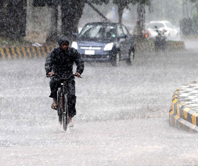
 Odisha Channel Bureau Bhubaneswar, Oct 11: Cyclone Hudhud advanced towards Odisha and Andhra Pradesh coast on Saturday before it hits Odisha-Andhra Pradesh coast with heavy rains accompanied by wind speed gusting to 185 kmph on Sunday.“The very severe cyclonic storm `HUDHUD’ is now lying within the range of Doppler Weather Radar, Visakhapatnam.Hence it is being tracked by Visakhapatpam Radar since early morning of today (Saturday) in addition to satellite and other observational tools.“According to latest observations, the very severe cyclonic storm `HUDHUD’ over westcentral Bay of Bengal moved westnorthwards and lay centred at 0530 hours IST of October 11 near Lat 15.9°N and Long 85.7°E about 330 kms southeast of Vishakhapatnam and 380 kms southsoutheast of Gopalpur.“The system would move westnorthwards for some more time.It would then move northwestwards and cross north Andhra Pradesh coast around Visakhapatnam by the forenoon of October 12,” according to the India Meteorological Department bulletin.October 11 (Day 1): Heavy to very heavy rainfall would occur at a few places with isolated extremely heavy fall over north coastal Andhra Pradesh and south Odisha and at isolated places over south coastal Andhra Pradesh and rest Odisha.Squally wind speed reaching 5060 kmph gusting to 70 kmph would prevail along and off north Andhra Pradesh and south Odisha coasts.Wind speed would gradually increase to 140-150 kmph gusting to 165 kmph around the time of landfall along and off north Andhra Pradesh and 80-90kmph along and off south Andhra Pradesh and south Odisha.Fishermen are advised not to venture into the sea off Andhra Pradesh & Odisha coasts.October 12 (Day 2): Heavy to very heavy rainfall would occur at a few places with isolated extremely heavy fall over north coastal Andhra Pradesh and south Odisha.Heavy to very heavy rainfall would occur at isolated places over south coastal Andhra Pradesh and rest Odisha.Heavy rainfall would occur at isolated places over Gangetic West Bengal, Jharkhand and Telangana.Wind speed reaching 140150 kmph gusting to 165 kmph would commence along and off north Andhra Pradesh coast and 80-90 kmph along and off south Andhra Pradesh coast and south Odisha.Fishermen are advised not to venture into the sea off Andhra Pradesh & Odisha coasts.Storm surge of about 12 metres above astronomical tide would occur around the system center of north coastal Andhra Pradesh at the time of landfall.October 13 (Day 3): Heavy to very heavy rainfall would occur at isolated places over Odisha, Gangetic West Bengal, Jharkhand, Chhattisgarh and Telangana.Fishermen are advised not to venture into the sea off Andhra Pradesh & Odisha coasts.Meanwhile, Odisha Government started evacuating people from seaside villages and low lying areas, and kept the administration ready to meet any challenge posed by the possible cyclone in several coastal districts as well as southern Odisha districts of Ganjam, Gajapati, Rayagada, Koraput, Malkangiri, Nabarangpur, Kalahandi and Kandhamal.Rainfall was continuing in several coastal districts since Friday making life miserable for the people in many areas in the region.
October 11, 2014
October 11, 2014
0 Comment
Related Articles:
- 5T Secretary reviews progress on CMO district visit grievance redressal
September 13, 2023, 11:47 am
- Patnaik announces Rs 10 lakhs each to Asian Game qualified Odisha athletes
September 13, 2023, 8:13 am
- Odisha CMO reviews grievances related to industrial development
September 12, 2023, 1:10 pm
- Odisha accelerates economic growth with approval of 9 key industrial projects
September 12, 2023, 4:02 am
- Odisha government is committed to welfare of animals: Patnaik
September 8, 2023, 4:18 pm
- Naveen Patnaik felicitates visually-challenged cricket players
September 8, 2023, 2:59 pm
- Odisha panchayat polls: Landslide victory for BJD, BJP distant second
March 1, 2022, 12:33 pm
- Hemananda Biswal: An inspiration for tribal leaders of Odisha
February 26, 2022, 5:17 am
- Hemananda Biswal passes away, to be cremated at his native place
February 26, 2022, 5:10 am
- Urban civic polls in Odisha to be held on March 24
February 25, 2022, 6:03 pm
Breaking News:
- Trump’s DOJ charged hundreds with assaulting officers. Many cases were dropped, but the damage was done
July 30, 2026, 11:25 am - Dangerous Heat Set to Shatter Even More Records Across US
July 30, 2026, 11:10 am - His son was just sentenced to life without parole for a school shooting. Today, Colin Gray learns his own fate
July 30, 2026, 10:10 am - I drove the Slate truck. Its toy-like looks hide a surprisingly serious pickup.
July 30, 2026, 9:31 am - Mamdani’s pied-à-terre tax was designed to hit the wealthy, but it’s sending most New Yorkers to their estate lawyers
July 30, 2026, 6:50 am - 'I milked the cows the day after getting married'
July 30, 2026, 5:08 am - Trump: Supreme Court tariff, birthright citizenship rulings costing country ‘trillions and trillions of dollars’
July 30, 2026, 2:02 am - Joe Rogan warns liberals against trying to turn Texas blue, says it would wreck the state's 'delicate balance'
July 30, 2026, 12:52 am - FCC chair defends new U.S. ban on foreign-made humanoid robots, a market China dominates
July 29, 2026, 11:25 pm - Police: Bullets that killed 2 bystanders at Seattle festival weren't from teen shooter's gun
July 29, 2026, 11:10 pm


